
5 Things You Should Know Before Climbing Mount Ulap
Blog Updated on November 14, 2021 by
*This post is not intended to encourage people to climb Mount Ulap without proper education and knowledge about the site, but rather, to inform you, readers, that the Cordilleran Mountains are slowly being damaged by human activity. If ever you’ll be visiting this mountain site, be sure to be a #ResponsibleTraveler*
Here are some facts and other things you should know before climbing Mount Ulap
1. The official name of the site is Ampucao – Sta. Fe Ridge Eco-Trail

Contrary to popularized belief, many people have been calling the place “Philex Ridge.” The Ampucao-Sta. Fe Ridge is one of the ridges on the famous seven peaks in the Cordillera Region – one of which is Mount Ulap. The Ridge was formally opened to the public, mainly to mountain enthusiasts, last October 30, 2015, although many climbers have trekked the ridge even before the formal launch.
2. The Ampucao – Sta. Fe Ridge has Three Peaks
The Ambanao Paoay Peak

With a height of 1,788 meters above sea level, the Ambanao Paoay Peak is the first peak on the ridge. It can be reached at around 2 hours or so, depending on your hike pace (see our detailed itinerary HERE!) The terrain is mainly grassy, many young pine trees thrive in the area and the vegetation is quite rich – a perfect place to graze some cows. Upon reaching the summit of Ambanao Paoay, some rock formations start to appear. You can also find an improvised comfort room before reaching the summit.
The Gungal Peak
The Gungal Peak stands at 1,814 meters above sea level and is the ‘center peak’ of the Ridge. The terrain from Ambanao Paoay is still grassy, with a diminishing number of pine trees in the area. Upon reaching the peak, the terrain becomes rocky. The peak can be reached in an hour or so, from Ambanao Paoay.
On Gungal’s summit, you can find stone stacks that have been done by previous climbers. (Vandalism has become rampant, too – just don’t do it.) You can make your own stone stacks there and see a panoramic view of Philex Mines, Mount Sto. Tomas, Mount Cabuyao, Mount Ugo and Pulag from afar, and Baguio City. You can also see the Lingayen Gulf straight ahead if the skies are clear. The summit of Mount Ulap can also be seen from this peak.
Mount Ulap

Mount Ulap is the Ridge’s main attraction. With a height of 1,846 meters above sea level, it is believed to be the highest in all the ‘seven peaks.’ Mount Ulap can be reached in an hour, too, from Gungal, except if you decide to rest and have lunch in the second peak. The terrain in Mount Ulap is a combination of grassy and rocky, with the addition of steep and slippery slopes, especially in Station 8 (Pong-ol) and 9 (Tiking).
There you can also see cows resting on some rock formations in Mount Ulap. If you need a bladder break, there is one improvised, unisex comfort room found on the base of the third peak. There is also a famous rock formation that resembles that rock on the movie Lion King. (I personally call it the “Lion King Rock”)
Turista Boy Tip:
It is better to climb the Ridge on Weekdays because there are lesser people climbing. On weekends (and holidays), there are approximately around 300-400 climbers, making the routes congested thus creating traffic, extending the hike hours.
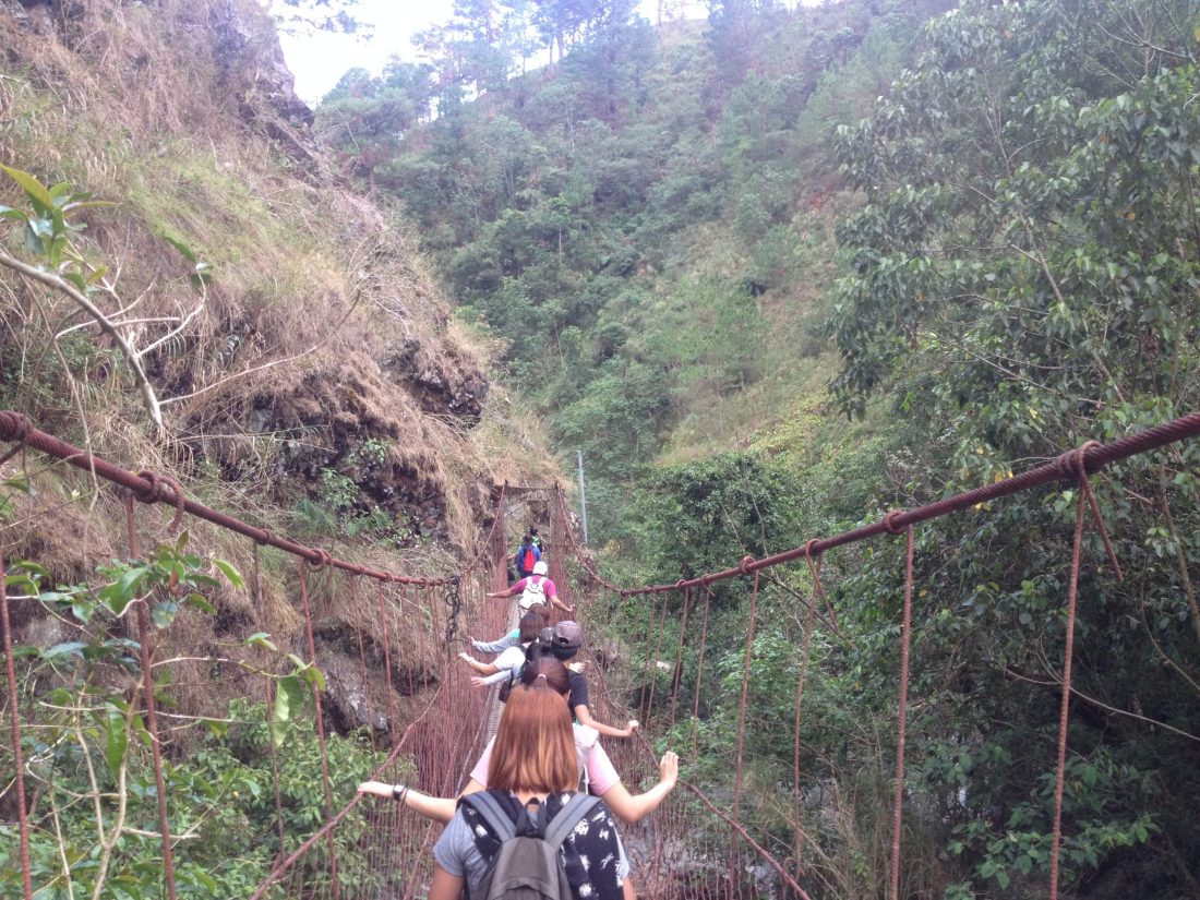
3. The Eco-Trail has 9 stations:
(Hiking times going to the Stations are indicated in approximation)
a) Sitio Bet-ang (10 minutes)
- It is where the registration for the climb happens (Barangay Ampucao Hall). It is also where they will assign you your climb guide.
b) Sitio Tumtumbek (20 minutes)
c) Sitio Kural (40 minutes)
- Commonly referred as ‘Kudal’ by locals – this is the place where grazed cows are being tattooed. The station has 1 improvised comfort room.
d) Ambanao Paoay (1 hour 15 minutes)
- The First Peak. According to our guide, “Ambanao” means ‘wide’ – wide and panoramic view of Mount Cabuyao and Mount Sto. Tomas and overlooking Baguio City.
e) Gungal Rock (30 minutes to 1 hour)
- The Second Peak. This is where you will find stone stacks (and you can make one, too!) and a perfect view of Philex Mines, Mount Ugo and Pulag from afar, Mount Ulap, and Lingayen Gulf (on clear sky conditions).
f) Puyod (30 minutes)
g) Mount Ulap (30 – 45 minutes)

- The Third Peak. Mount Ulap was surveyed by a man named “Mr. Lagman” sometime in the 1930s and named it ‘Ulap’ because there were many clouds when he came up to survey the place. In the Filipino vernacular, “Ulap” means ‘cloud’ in English. There is also an improvised comfort room at the base of the peak, going to Station 8 (Pong-ol).
OPTIONAL Stations:
h) Pong-ol (45 minutes to 1 hour)
- It literally means “meeting place” in the ancient Igorot dialect. This Station used to be the meeting place of the ancient Igorot tribes to hold their grand cañaos.

i) Tiking (1 hour to 1 hour 30 minutes)
- Tiking means “coffin” in the olden times. This station is where some burial caves are situated. In Stations 8 and 9, there are at least 3 accessible burial caves but the terrain / trail is very rocky and slippery and is very dangerous on some parts. You also have to rappel twice or thrice to reach some of the mini-caves.
Turista Boy Tip:
Ask your guide about the 9 Stations of the Ridge. I may have slipped into some information in this post. They will tell you everything about the Ridge.
4. There are two hike options going to the Eco-trail
*The Ampucao – Sta. Fe Ridge Traverse
- The route from the Ampucao Barangay Hall to Barangay Sta. Fe has a length of 13 Kilometers.
- Groups can camp overnight at the Ambanao Paoay peak for PhP 700 – 800; it is also advisable to bring your own tents and other gear (inform persons-in-charge at the registration area) because there are no tent and other camping gear rentals in the area.
- Hikers can either choose Barangay Sta. Fe or Barangay Ampucao as Entry and Exit points.
- Hiking time is roughly around 6 – 8 hours, according to your hike pace.
*The “Balikan” Route
- The route from Ampucao Barangay Hall to Ambanao Paoay and/or Gungal Peak has a length of 9 Kilometers.
- Hiking time is roughly around 4 – 5 hours, according to your hike pace and will return to the Barangay Hall after.
5. In the lesser-known ‘Seven Peaks,’ Mount Ulap is believed to be the highest among them.
*We’ll update this as long as we’re able to extract additional information about the 7 peaks.* 🙂
With a height of 1,846 meters above sea level, you get to see a panoramic view of Baguio City, Mount Sto. Tomas, Philex Mines, Binga Dam, the municipality of Tuba, and in clear skies, the Lingayen Gulf. You can also see Mount Ugo and Mount Pulag from afar.
In Mount Ulap, there are a few grazers taking care of their cows, an added attraction in the area. Also in the afternoon, fog kisses the mountain tops making the temperature a lot cooler.
The over-all terrain of the Ridge is grassy below and rocky (slippery), steep slopes on the peaks (especially in stations 8 (Pong-ol) and 9 (Tiking)).


FRIENDLY REMINDER
Be mindful of your garbage when hiking to the Ridge, it is very disappointing to see that there are many garbage scattered along the trail. When our guide picked these clutters during our trek, she filled an entire plastic bag of garbage.
Be sensitive to the culture of the locals. It does not mean that if you’re from a different place, you have the right to act differently. Remember, you are just a visitor; it is still their place you are going to. Respect everything that they believe in.
If you have further inquiries about the Ampucao – Sta. Fe Ridge or Mount Ulap, you can contact the following key persons:
| Nestor Camado Jr.
(Municipal Tourism Officer – Designate) |
+63 999 336 7522 |
| Michelle Idio | +63 920 628 6370 |
| Jessica Floresca | +63 927 127 3834 |
| Maia Nalibsan
(Barangay Ampucao Secretary) |
+63 998 958 9549 |
We’re born to travel!

Comments
Post a Comment
You must be logged in to post a comment.
LoveEatWander
We’re climbing this mountain next month. Lucky to see this post. So detailed!
Shiela
Thanks for this post, Aunty Chiki! 😀
will use the info for my climb this week.
Pingback: 2016 - Turista Boy's Best (Travels and Experiences!) | Turista Boy
jedric
i will climb tomorrow… ☺☺☺
Aldrick 'chiki' Agpaoa
How was your climb, Jed? Gosh! Sana hindi blockbuster nung pumunta kayo?
Emy
I just climb Mt pamitinan n Mt hapunang banoi who for me is very risky. I’m 52 y o. NXT wk Feb 3 are our skedule for Mt ulap. Do u think I can manage to climb? My dream and interest now is to climb not all but Mt pulag. Is it OK at my age.?
Aldrick 'chiki' Agpaoa
Hi, Emy! Of course you can! 😀 Just bring lots of food and water! And bring a lot of feet power as well! 😀 Balitaan niyo po ako kung kumusta kayo after the climb!
Emy
Thanks for d info. Feb 3 is our skedule to climb. At my age 52 do u think I can? Hope so. I lve seeing ur reviews and d view of Mt. Ulap
Emy
Thanks for d info. Feb 3 is our skedule to climb Mt ulap.
Tet Lopez
sir, nice blog.. =) we’re planning to climb mt. ulap this Fe. 18-19… blockbuster po ba talaga? pero manageable naman po ba ung crowd? kc me kasama kami mga bago. baka madala.. hehe.. sana not like Mt. Pamitinan last Jan. 28. sobrang traffic sir! :-p
Joms
Very informative sir. Thanks for da info.we hav a sched climb for Mt. Ulap dis Feb 25.jus a dayhike.since trail is grassy wala po bang mga ahas sa mga dadaanan or any ader wild n dapat ktakutan?thnks